October 25 – Written By Michael Sparks
The National Park Where Preservation Isn’t The Goal
Assateague Island National Seashore Is Content To Let Nature Take Its Course
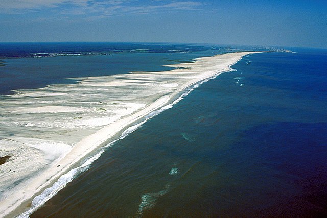
BERLIN, MD – The Grand Canyon isn’t moving. It’s been right where it is for millions of years. True, it’s eroding and changing, but so slowly as to be imperceptible. Even less so now that the Colorado River–the canyon’s primary sculptor–is at record lows. Off the coast of Maryland, though, a narrow barrier island has moved a quarter-mile west in the past 40 years.
I went to Assateague Island National Seashore, on the northern portion of the island, to learn about how coastal national parks are adapting to climate change. I spent an afternoon in late September with the park’s Superintendent, Hugh Hawthorne, and the park’s Chief of Resources, Bill Hulslander. What I came away with was not just a better understanding of how the park is adapting to climate change, but also with a feeling that I had stumbled upon something special–a national park unit unlike any other.
The size and stillness of the Grand Canyon fix your gaze, like staring over the rim into a scene from a long distant past. Assateague, on the other hand, draws you in because the island is alive and you can feel it breathing underneath you. Its lungs of water and wind constantly contracting and expanding, pushing around sand and dunes and coastline.
Assateague shoreline 1985
Assateague shoreline 2019
One of the last undeveloped shorelines on the east coast, Assateague is a critical natural habitat for hundreds of species, including fish, reptiles, and birds migrating along the Atlantic Flyway from Maine to Florida. It helps protect the developed mainland from extreme storms and tidal surges, and is one of the premier outdoor recreation spots in the mid-Atlantic.
It is also one of, if not the, most dynamic units in the National Park Service. Assateague Island National Seashore encompasses the majority of the island and most of the water immediately surrounding it. Low, narrow, and 37-miles long, the island was formed in 1933 after a major storm cut an inlet across the existing peninsula south of Ocean City. Unlike islands made of rock, barrier islands like Assateague are made of sand–sand that is constantly shifting because of winds and waves. “Natural processes are our reason for being,” Hawthorne, the park’s Superintendent, said.
As Hawthorne, Hulslander and I stood on the beach, Hulslander pointed over a dune towards the ocean and explained that the island serves as a buffer for the mainland and mitigates flooding and tidal surge. When a storm rolls in, “the island mutes the energy. Just a little, but sometimes a little is enough,” he said. As an example, Hawthorne added that one of the many reasons Louisiana experiences such bad flooding is that its barrier islands are eroding at an extreme rate and don’t provide as much protection for the mainland as an island like Assateague does.
Aside from the beach, fishing, and hunting, Assateague’s two million yearly visitors come to watch the abundant wildlife, the most well-known of which are the beautiful wild horses (there are 83 in the seashore’s herd right now, and more elsewhere on the island). Deer and several species of frogs and reptiles also live on the island. Assateague also provides abundant food and a place to rest for thousands of birds on their twice-yearly trans-continental migration.
It’s not just island tourism that helps keep the local economy humming. According to the National Park Service, “the sheltered, nutrient rich waters of the estuary formed by the island provide ideal breeding and spawning habitat for many aquatic species, some of which, like the blue crab, are commercially important to the local area.”
All of these benefits of the island–economic, ecological, recreational–are threatened by climate change. Even though change is the very nature of the seashore, too much change too fast could be devastating. “Some movement is normal,” Hawthorne said, but climate change is speeding things up via sea level rise and more intense storms.
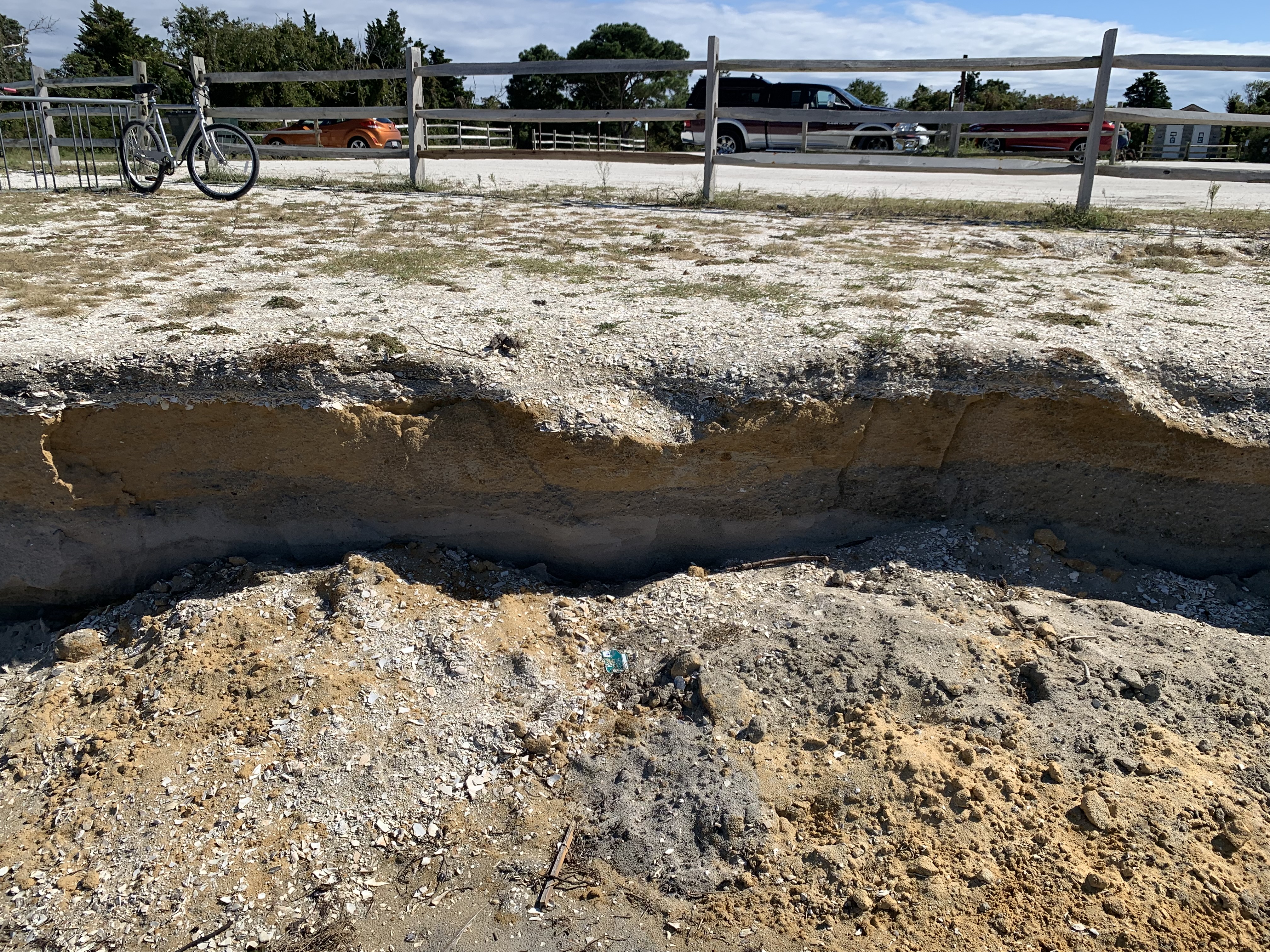
The U.S. Geological Survey (USGS) says that, on the high end, Maryland can expect over two feet of sea level rise by 2050. And according to the National Park Service’s Climate Change Response Program, “rising sea levels can worsen erosion, permanently inundate wetlands, and destroy habitat for diverse wildlife and plants.” I saw firsthand how erosion is wearing away the parking lots at Assateague’s Bayside Campground. A giant chunk had fallen off, exposing more than a foot of clay and soil underneath. It reminded me of the layers in a slice of cake. Eventually, that parking lot will need to be moved further away from the coastline.
Over the past few years, Assateague has also needed to relocate several campsites from its other campground, the accurately named Oceanside Campground, to a more stable location on the island. Oceanside is “extremely vulnerable” to the island’s westward movement, according to the park’s 2018 Flexible Design Strategy Environmental Assessment, which calls for moving campsites incrementally as they become lost to the shifting coastline.
As sea levels rise, they increase the salinity of the nutrient-rich coastal waters and marshes surrounding the island, particularly of Sinexupent Bay, on the island’s west side. These areas tend to receive lots of freshwater runoff from the mainland and the combination of salt and freshwater creates a delicate balance that continually recharges the ecosystem and supports marine life. A July 2021 report by the USGS and NPS predicts that in the worst-case sea level rise scenario, the island’s lowest marshes will all convert to primarily saltwater, greatly endangering the island’s marine ecosystem.
As if rising seas weren’t enough, Assateague is also sinking. The sinking, or subsidence, is caused by groundwater withdrawal (water sources for homes and businesses are depleting groundwater, which causes the land to sink) and glacial subsidence (basically, the area is still resettling after the last ice age). Together, subsidence and sea level rise narrow the coastline and erode dunes, which lessens the island’s natural resilience and compounds climate change effects on Assateague, according to Hulslander.
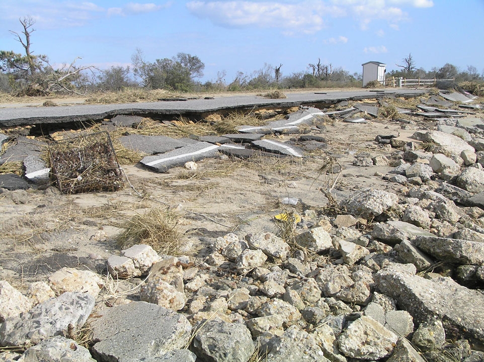
In addition to the creeping tick-tock of sea level rise, major storm events can alter the seashore’s entire landscape overnight. Extreme storms increase the likelihood of major flooding, erosion, and overwash (when water deposits large amounts of sand towards the island’s interior) all at once, Hulslander said. Because of the damage it caused, Hurricane Sandy, for instance, was a major turning point in the park’s management philosophy. “Sandy was a kick in the butt,” Hulslander lamented. Before Sandy, Assateague’s management figured the island was mostly safe from major storms, but afterwards “it was clear we were going to have to manage for that.” In its wake, Sandy left major damage to several man-made structures on the island: there was five feet of sand in the Oceanside Campground parking lot, flooding closed large areas of the park for weeks, the only bridge to the island’s north side was damaged, and boardwalks, trails, and other visitor facilities were all damaged. “Prior to Sandy, the philosophy was ‘west is best.’ But Sandy taught us a new lesson. We’re squeezed from the east. And squeezed from the west.”
Hurricane Sandy gave the park a lot more than it anticipated. Natural resources destroyed? check. Man-made resources damaged? check. Management philosophy changed? Check.
“We had just started writing out our new General Management Plan right before Sandy and we were already going in this direction, but it was so clear that our whole GMP had to be within the context of climate change, which was a new thing for the park service,” Hulslander told me while we were standing on what used to be an asphalt parking lot, until Hurricane Sandy came through. If you didn’t know a parking lot used to be here, though, you would never be able to tell. The island has totally reclaimed the area. And that represents exactly what has been so pioneering about Assateague Island National Seashore’s approach to dealing with climate change. “Our approach has been building a more healthy ecosystem, which makes the island more resilient,” Hulslander explained, a note of pride in his voice.
But being a pioneer isn’t always easy. “Lots of people don’t want to hear that you can’t fight…There are people who think we can solve anything with engineering,” Hawthorne told me. “One option in the GMP was to hold the line” and not move any of the park’s facilities from their current positions. “It would cost millions and work for maybe 20 years.”
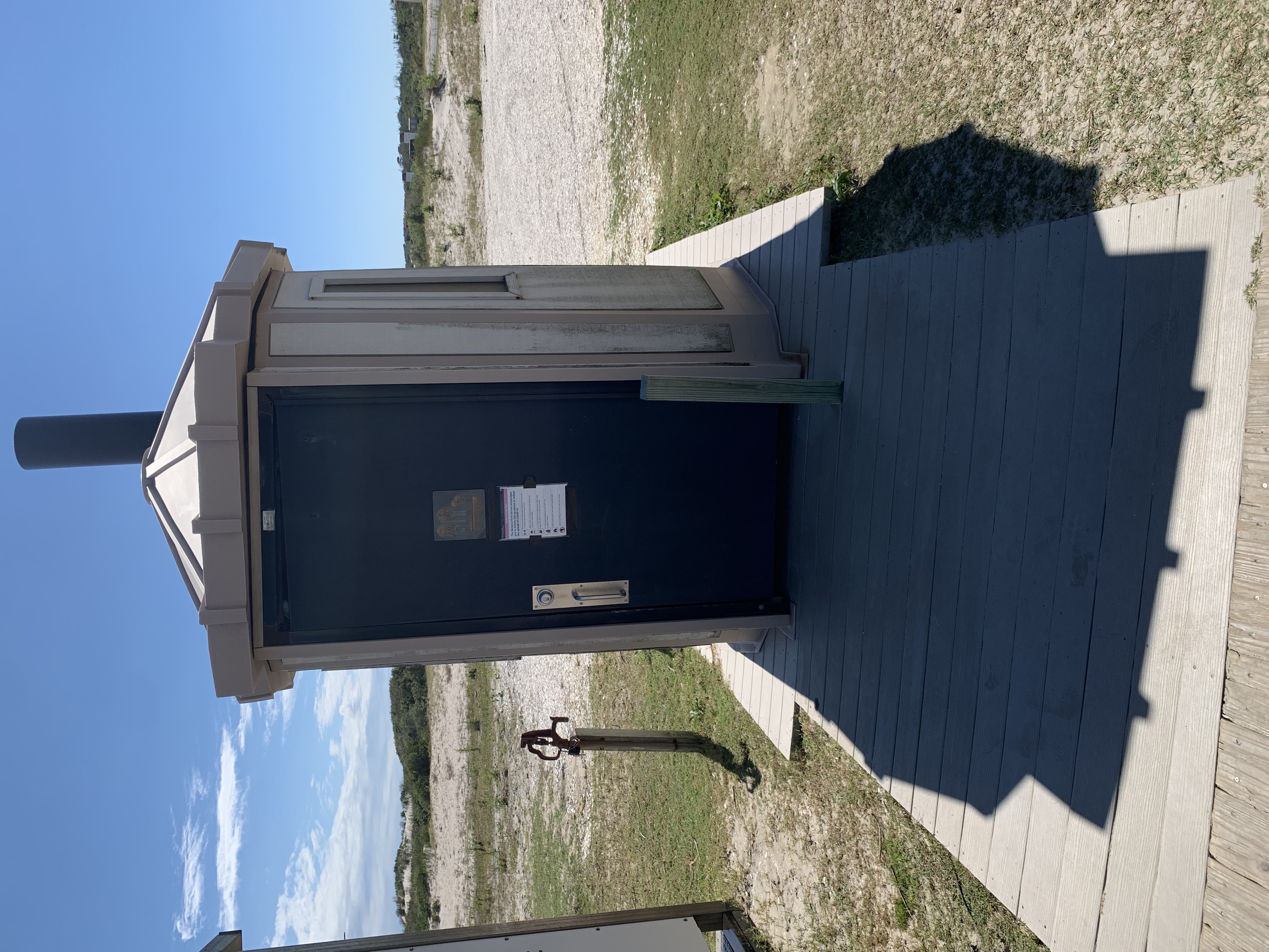
In fact, part of Assateague’s management’s uniqueness, aside from its philosophy of “let nature take its course” is its emphasis on renewable and moveable man-made structures. There’s “no need for a $40 million building if a $2 million building does the same thing and we can move it,” Hawthorne said nonchalantly.
The park’s bathrooms and showers are on pallets and “can basically be removed as long as you have a bobcat with a forklift,” Hulslander told me as we walked out onto the beach to look at them. Moving them off the island before a major storm is crucial, because it prevents the structures from being damaged (and needing costly repairs) or, worse, breaking apart and polluting the local habitats.
In a remarkable feat of creativity, Assateague now builds parking lots and roads from island-compatible materials: a clay base with clam shell surface. These more natural lots are dug up and reused when the lot is moved or overwashed, and also avoid introducing toxic foreign debris (aka asphalt) into post-storm habitats.
As successful as Assateague has been, it isn’t without challenges. As is frequently the case with any large institution, those challenges are man-made and involve money.
First, Assateague (and any national park unit) has to go through an extensive planning process. The park will usually design plans on a 5-7 year horizon. If a project touches cultural or natural resources, it requires a more rigorous planning process to make sure they’re checking all the boxes and don’t overlook anything that could have unintended consequences. “Going through the process is helpful…It gives us sideboards,” Hulslander said. As an example, he pointed to the clay and clamshell parking lot we were standing on. Fixing it, “wouldn’t require a process...But if we wanted to expand it we would have to” go through a planning process with outside partners.
Even once a project plan is complete, it might not be implemented for years until the project can be properly funded. Speaking still of the parking lots, Hawthorne told me about a plan to remove an asphalt lot from a campground in the park and replace it with a clay and clamshell one. But it’s funding dependent, he said. “Could be 2-3 years or could be 5-6.”
Anything over half a million dollars goes as a line item in the Congressional budget (and gets more scrutiny), so that is an important cutoff point. At this level, projects are funded via “soft money,” Hawthorne explained. “The park has to submit a proposal and the NPS picks out the projects that get funded…Trying to get money from different funding sources is a big part of my job.” And one of the biggest challenges is trying to convince higher-ups at the National Park Service, but getting pushback because they “don’t want to change how we plan or how we fund.”
The problem with this project-dependent funding style is that it is hard to quantify exactly when the park will need to take on a big infrastructure project, like replacing a parking lot that has eroded away. Hawthorne gestured at a major piece of parking lot that had washed away: “It could be 2 years or 6 years or it could be after a big storm event...I can’t tell you when the flooding is going to occur, but I can tell you that flooding will occur within the next 10 years.” This problem isn’t unique to Assateague. Parks out west don’t know exactly when flash floods or forest fires are going to hit. But it is especially pronounced at Assateague because of the rate of change. “Our time frames are more compressed than other parks,” Hawthorne said.
There’s a reason the Grand Canyon is probably the most famous landscape in America and maybe even the world. It is full of awe-inspiring vistas and panoramas. Spectacular colors and million-year-old geological formations. It is home to a wide range of ecosystems and animals. Its sheer size and beauty make it worthy of its fame.
When visitors gaze over the edge of the canyon, what they see is very similar to what was there tens of thousands of years ago. It is the epitome of preservation and there is a kind of grandeur in that. Assateague Island National Seashore couldn’t be more different. A visitor today sees something very different than a visitor last year, much less a visitor 40 years ago. One hundred years ago, it wasn’t even an island. But it is one of the most dynamic and fascinating parks in the National Park Service and it is alive. Moving. Changing every day. And there is a kind of grandeur in that, as well.